Space News
space history and artifacts articles

Messages
space history discussion forums

Sightings
worldwide astronaut appearances

Resources
selected space history documents

Forum:Satellites - Robotic Probes
Topic:NASA's Mars Reconnaisance Orbiter (MRO)
Want to register?
Who Can Post? Any registered users may post a reply.
About Registration You must be registered in order to post a topic or reply in this forum.
Your UserName:
Your Password:   Forget your password?
Your Reply:


*HTML is ON
*UBB Code is ON

Smilies Legend

Options Disable Smilies in This Post.
Show Signature: include your profile signature. Only registered users may have signatures.
*If HTML and/or UBB Code are enabled, this means you can use HTML and/or UBB Code in your message.

If you have previously registered, but forgotten your password, click here.

"The best explanation for these observations so far is the flow of briny water," said Alfred McEwen of the University of Arizona, Tucson. McEwen is the principal investigator for the orbiter's High Resolution Imaging Science Experiment (HiRISE) and lead author of a report about the recurring flows published in Thursday's edition of the journal Science.

Some aspects of the observations still puzzle researchers, but flows of liquid brine fit the features' characteristics better than alternate hypotheses. Saltiness lowers the freezing temperature of water.

Sites with active flows get warm enough, even in the shallow subsurface, to sustain liquid water that is about as salty as Earth's oceans, while pure water would freeze at the observed temperatures.

"These dark lineations are different from other types of features on Martian slopes," said MRO project scientist Richard Zurek of NASA's Jet Propulsion Laboratory in Pasadena, Calif. "Repeated observations show they extend ever farther downhill with time during the warm season."

The features imaged are only about 0.5 to 5 yards or meters wide, with lengths up to hundreds of yards. The width is much narrower than previously reported gullies on Martian slopes. However, some of those locations display more than 1,000 individual flows. Also, while gullies are abundant on cold, pole-facing slopes, these dark flows are on warmer, equator-facing slopes.

The images show flows lengthen and darken on rocky equator-facing slopes from late spring to early fall. The seasonality, latitude distribution and brightness changes suggest a volatile material is involved, but there is no direct detection of one. The settings are too warm for carbon-dioxide frost and, at some sites, too cold for pure water. This suggests the action of brines which have lower freezing points. Salt deposits over much of Mars indicate brines were abundant in Mars' past. These recent observations suggest brines still may form near the surface today in limited times and places.

When researchers checked flow-marked slopes with the orbiter's Compact Reconnaissance Imaging Spectrometer for Mars (CRISM), no sign of water appeared. The features may quickly dry on the surface or could be shallow subsurface flows.

"The flows are not dark because of being wet," McEwen said. "They are dark for some other reason."

A flow initiated by briny water could rearrange grains or change surface roughness in a way that darkens the appearance. How the features brighten again when temperatures drop is harder to explain.

"It's a mystery now, but I think it's a solvable mystery with further observations and laboratory experiments," McEwen said.

These results are the closest scientists have come to finding evidence of liquid water on the planet's surface today. Frozen water, however has been detected near the surface in many middle to high-latitude regions. Fresh-looking gullies suggest slope movements in geologically recent times, perhaps aided by water. Purported droplets of brine also appeared on struts of the Phoenix Mars Lander. If further study of the recurring dark flows supports evidence of brines, these could be the first known Martian locations with liquid water.

MRO is managed by JPL for NASA's Science Mission Directorate in Washington. The University of Arizona's Lunar and Planetary Laboratory operates HiRISE. The camera was built by Ball Aerospace & Technologies Corp. in Boulder, Colo. Johns Hopkins University Applied Physics Laboratory in Laurel, Md., provided and operates CRISM.

See here for discussion of possible water flows on Mars
Robert PearlmanNASA release
Prolific Mars Orbiter Completes 50,000 Orbits

The most data-productive spacecraft yet at Mars swept past its 50,000th orbit this week, continuing to compile the most sharp-eyed global coverage ever accomplished by a camera at the Red Planet.

In addition, the spacecraft — NASA's Mars Reconnaissance Orbiter — recently aided preparations for NASA's next mission to Mars, the InSight lander. Insight will launch next year on a mission to study the planet's deep interior. Meanwhile, the orbiter continues diverse science observations of Mars and communications-relay service for two active Mars rovers, Curiosity and Opportunity.

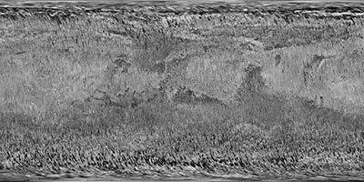
Above: The Context Camera on NASA's Mars Reconnaissance Orbiter has been taking images of Mars for more than 10 years, sharp enough to show the shapes of features as small as a tennis court. The compiled images from CTX now cover more than 99 percent of Mars.

MRO's Context Camera (CTX) exploits a sweet spot in the balance between resolution and image file size. With a resolution of about 20 feet (6 meters) per pixel in images of the Martian surface, it has provided a library of images now covering 99.1 percent of Mars. That is approximately equivalent to the land area of Earth. No other camera ever sent to Mars has photographed so much of the planet in such high resolution.

The Context Camera has taken about 90,000 images since the spacecraft began examining Mars from orbit in late 2006. Each one reveals shapes of features down to sizes smaller than a tennis court, in a swath of ground about 18.6 miles (30 kilometers) wide.

"Reaching 99.1-percent coverage has been tricky because a number of factors, including weather conditions, coordination with other instruments, downlink limitations, and orbital constraints, tend to limit where we can image and when," said Context Camera Team Leader Michael Malin of Malin Space Science Systems, San Diego.

In addition to observing nearly the entire planet at least once, the Context Camera has observed 60.4 percent of the planet more than once. These observations aid science directly and also certify the safety of future landing sites.

Malin said, "Single coverage provides a baseline we can use for comparison with future observations, as we look for changes. Re-imaging areas serves two functions: looking for changes and acquiring stereoscopic views from which we can make topographic maps."

A dramatic type of change the Context Camera has documented more than 200 times is a fresh impact crater appearing between the times of two observations. These images enabled scientists to calculate the rate at which small asteroids, or bits of comets, are colliding with Mars. Some of the fresh impacts reveal white material interpreted as water ice. The latitudes and estimated depths of the ice-exposing craters provide evidence about the distribution of buried ice near the surface. MRO's Shallow Radar has found ice farther underground, but this very shallow ice would go undetected if not for its exposure by impacts.

One of MRO's other cameras, the High Resolution Imaging Science Experiment (HiRISE), can zoom in on the new impact craters found by the Context Camera. For some of these craters, HiRISE and MRO's Compact Reconnaissance Imaging Spectrometer for Mars have confirmed the presence of water ice. However, even though MRO has returned more than 300 terabits of science data, the much higher spatial resolution of HiRISE has limited its coverage of Mars' surface to about three percent. A third MRO camera, the Mars Color Imager, observes almost the entire planet every day to track weather change. Another instrument, the Mars Climate Sounder, records vertical profiles of the atmosphere's temperatures and suspended particles.

The spacecraft was launched Aug. 12, 2005. It entered an elongated orbit of Mars in March 2006, then spent several months using friction with Mars' upper atmosphere to revise its orbit. Since beginning its science operations in November 2006, MRO has been flying near-polar orbits lasting about two hours, at altitudes from 155 to 196 miles (250 to 316 kilometers). The mission completed its 50,000th orbit on Monday, March 27.

"After 11 and a half years in flight, the spacecraft is healthy and remains fully functional," said MRO Project Manager Dan Johnston at NASA's Jet Propulsion Laboratory, Pasadena, California. "It's a marvelous vehicle that we expect will serve the Mars Exploration Program and Mars science for many more years to come."

On March 22, the mission made the latest adjustment to the orbit, with a 45.1-second burn of six intermediate-size rocket engines, each of which provides 5 pounds (22 newtons) of thrust. This maneuver revised the orbit orientation, so that the spacecraft can be at the right place at the right time, on Nov. 26, 2018, to receive critical radio transmissions from NASA's InSight Mars lander as it descends to the surface.

MRO has already provided more than 60 images from HiRISE for advance analysis of the landing region for InSight. In a broad plain of the Elysium Planitia region of equatorial Mars, InSight will use a seismometer and heat probe to examine the interior of Mars to better understand the formation process of rocky planets like Earth. The final MRO image for assessment of this landing area will be taken Thursday, March 30.

Robert PearlmanNASA release
Mars Reconnaissance Orbiter Preparing for Years Ahead

NASA's Mars Reconnaissance Orbiter (MRO) has begun extra stargazing to help the space agency accomplish advances in Mars exploration over the next decade.

The spacecraft already has worked more than double its planned mission life since launch in 2005. NASA plans to keep using it past the mid-2020s. Increased reliance on a star tracker, and less on aging gyroscopes, is one way the mission is adapting to extend its longevity. Another step is wringing more useful life from batteries. The mission's extended service provides data relay from assets on Mars' surface and observations with its science instruments, despite some degradation in capabilities.

"We know we're a critical element for the Mars Program to support other missions for the long haul, so we're finding ways to extend the spacecraft's life," said MRO Project Manager Dan Johnston of NASA's Jet Propulsion Laboratory, Pasadena, California. "In flight operations, our emphasis is on minimizing risk to the spacecraft while carrying out an ambitious scientific and programmatic plan." JPL partners with Lockheed Martin Space, Denver, in operating the spacecraft.

In early February, MRO completed its final full-swapover test using only stellar navigation to sense and maintain the spacecraft's orientation, without gyroscopes or accelerometers. The project is evaluating the recent test and planning to shift indefinitely to this "all-stellar" mode in March.

From MRO's 2005 launch until the "all-stellar" capability was uploaded as a software patch last year, the spacecraft always used an inertial measurement unit -- containing gyros and accelerometers -- for attitude control. At Mars, the orbiter's attitude changes almost continuously, with relation to the Sun and other stars, as it rotates once per orbit to keep its science instruments pointed downward at Mars.

The spacecraft carries a spare inertial measurement unit. The mission switched from the primary unit to the spare after about 58,000 hours of use, when the primary began showing signs of limited life several years ago. The spare shows normal life progression after 52,000 hours, but now needs to be conserved for when it will be most needed, while the star tracker handles attitude determination for routine operations.

The star tracker, which also has a backup on board, uses a camera to image the sky and pattern-recognition software to discern which bright stars are in the field of view. This allows the system to identify the spacecraft's orientation at that moment. Repeating the observations up to several times per second very accurately provides the rate and direction of attitude change.

"In all-stellar mode, we can do normal science and normal relay," Johnston said. "The inertial measurement unit powers back on only when it's needed, such as during safe mode, orbital trim maneuvers, or communications coverage during critical events around a Mars landing." Safe mode is a precautionary status the spacecraft enters when it senses unexpected conditions. Precise attitude control is then essential for maintaining communications with Earth and keeping the solar array facing the Sun for power.

To prolong battery life, the project is conditioning the two batteries to hold more charge, reducing demand on the batteries, and is planning to reduce the time the orbiter spends in Mars' shadow, when sunlight can't reach the solar arrays. The spacecraft uses its batteries only when it is in shadow, currently for about 40 minutes of every two-hour orbit.

The batteries are recharged by the orbiter's two large solar arrays. The mission now charges the batteries higher than before, to increase their capacity and lifespan. It has reduced the draw on them, in part by adjusting heater temperatures before the spacecraft enters shadow. The adjustment preheats vital parts while solar power is available so the heaters' drain on the batteries, while in shadow, can be reduced.

The near-circle of MRO's orbit stays at nearly the same angle to the Sun, as Mars orbits the Sun and rotates beneath the spacecraft. By design, as the orbiter passes over the sunlit side of the planet during each orbit, the ground beneath it is about halfway between noon and sunset. By shifting the orbit to later in the afternoon, mission managers could reduce the amount of time the spacecraft spends in Mars' shadow each orbit. NASA's Mars Odyssey spacecraft, older than MRO, successfully did this a few years ago. This option to extend battery life would not be used until after MRO has supported new Mars mission landings in 2018 and 2021 by receiving transmissions during the landers' critical arrival events.

"We are counting on Mars Reconnaissance Orbiter remaining in service for many more years," said Michael Meyer, lead scientist of NASA's Mars Exploration Program at the agency's Washington headquarters. "It's not just the communications relay that MRO provides, as important as that is. It's also the science-instrument observations. Those help us understand potential landing sites before they are visited, and interpret how the findings on the surface relate to the planet as a whole."

MRO continues to investigate Mars with all six of the orbiter's science instruments, a decade after what was initially planned as a two-year science mission to be followed by a two-year relay mission. More than 1,200 scientific publications have been based on MRO observations. Teams operating the two instruments named most often in research papers -- the High Resolution Imaging Science Experiment (HiRISE) camera and the Compact Reconnaissance Imaging Spectrometer for Mars (CRISM) mineral-mapper -- are dealing with challenges but are ready to continue providing valuable observations.

For example, some HiRISE images taken in 2017 and early 2018 show slight blurring not seen earlier in the mission. The cause is under investigation. The percentage of full-resolution images with blurring peaked at 70 percent last October, at about the time when Mars was at the point in its orbit farthest from the Sun. The percentage has since declined to less than 20 percent. Even before the first blurred images were seen, observations with HiRISE commonly used a technique that covers more ground area at half the resolution. This still provides higher resolution than any other camera orbiting Mars -- about 2 feet (60 centimeters) per pixel -- and little blurring has appeared in the resulting images.

Using two spectrometers, CRISM can detect a wide range of minerals on Mars. The longer-wavelength spectrometer requires cooling to detect signatures of many minerals, including some associated with water, such as carbonates. To do this during the two-year prime science mission, CRISM used three cryocoolers, one at a time, to keep detectors at minus 235 Fahrenheit (minus 148 Celsius) or colder. A decade later, two of the cryocoolers no longer work. The last has become unreliable, but is still under evaluation after 34,000 hours of operation. Without a cryocooler, CRISM can still observe some near-infrared light at wavelengths valuable for detecting iron oxide and sulfate minerals that indicate past wet environments on Mars.

The Context Camera (CTX) continues as it has throughout the mission, adding to near-global coverage and searching for changes on the surface. The Shallow Radar (SHARAD) continues to probe the subsurface of Mars, looking for layering and ice. Two instruments for studying the atmosphere -- the Mars Color Imager (MARCI) and Mars Climate Sounder (MCS) -- continue to build on nearly six Mars years (about 12 Earth years) of recording weather and climate.

Contact Us | The Source for Space History & Artifacts

Copyright 1999-2024 collectSPACE. All rights reserved.


advertisement